Peel Mining
Wirlong Project
Project Snapshot
Updated Mineral Resource January 2023
4.3 million tonnes at 1.75% copper and 6g/t silver containing approximately 75,000 tonnes of copper and 840,000 ounces silver (using an $A80/t NSR cut-off).
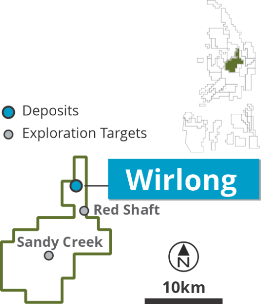
The Wirlong Copper Project straddles the boundary of Exploration Licences 8126 & 8307, and is located ~75km south of Cobar and ~30km southwest of Nymagee, NSW. Wirlong represents a classic Cobar-style Cu-Ag deposit. The deposit is situated on a 12,000-acre pastoral lease owned by Peel Mining and is ~30km north of Peel’s Mallee Bull Copper Project.
The Mineral Resource Estimate defines strong primary copper mineralisation commencing at ~60m below surface to over 600m below surface and across 320m & 560m strike length of two mineralised domains. Regionally, the Wirlong project has intercepted copper mineralisation along more than 2.5km strike length and to depths of 950m.
The Wirlong MRE reflects 66,092m of RC and diamond drilling completed by Peel since the deposit’s recognition in 2014.
Drilling at Wirlong is part of the Company’s “Hub & Spoke” strategy to advance each of the Company’s deposits to mineable resources, to achieve critical mass in support of a new substantial centrally located processing plant. The resource definition drill program comprises of up to ~11,000m of drilling and is anticipated to be completed in the March quarter of 2021.
Wirlong is located about 1.5km north of historic workings and is hosted in a N-S striking, moderate to steeply west dipping (~65o) sequence of interfingering sediments and volcanics that exhibit open to locally tight parasitic folds. The sediments comprise massive to locally laminated quartz-rich sandstones and interbedded shale, siltstone and sandstone turbidites of the Shume Formation. The volcanics comprise massive, porphyritic, flow-banded and auto-brecciated rhyolite of the Shuttleton Rhyolite Member. Soft sediment deformation, intense hydrothermal alteration, local hyaloclastites and peperitic margins are indicative of the rhyolite being emplaced as a very high-level sill into wet, semi-consolidated sediments. Age dating of the Shuttleton Rhyolite Member by Waltenberg et al (2016) suggests an age of 421.9 +/- 2.7Ma for the rhyolite which is consistent with the sequence forming during late Silurian to Early Devonian rifting related to the formation of the Cobar Super Basin. Field observations and younging data from drill core have delineated a westward-younging sequence that is bound to the east by the major N-S striking Woorara Fault.
The geological sequence at Wirlong is overprinted by a strong, consistently N-S striking foliation that dominantly dips steeply to the east, rotating to steeply west where proximal to the Woorara Fault. Evidence from bedding and younging data shows that the west dipping sequence of sediments and volcanics is parasitically folded, dominated by open to locally tight asymmetric style folds.
Wirlong is primarily hosted within a NW-SE striking fault zone (John Owen Fault) which is host to the high-grade MBX domain and is surrounded by a halo of stockwork copper mineralisation that remains spatially open. The John Owen Fault is observed at the surface by local gossanous float and as a series of isolated, massive quartz veins that range in thickness from <1m to over 10m. The fault has been mapped at the surface for a current strike length of over 1.3km and forms a conjugate structure set with a NE-SW striking fault that passes through the historic Wirlong shafts. Peel hypothesises the faults formed during E-W compression during basin inversion that gave rise to conjugate fault sets that are consistent with a Riedel shear model.
Mineralisation at Wirlong is hosted in all lithologies and comprises massive to semi-massive breccia-fill and vein hosted chalcopyrite-pyrrhotite-pyrite (+/- arsenopyrite, sphalerite, galena). In the oxide zone azurite, malachite, chalcocite and smithsonite are observed. Intense Fe-Mg chlorite alteration is spatially associated with chalcopyrite-rich mineralisation. Structural analysis indicates that the intersection of the NW-SE striking John Owen Fault with the regional trending N-S orientation created local zones of dilation that facilitated the movement and emplacement of mineralising fluids into structures and faults (MBX domain) and fractures and foliation (Stockwork domains).
Strong copper mineralisation is thought to form a series of stacked, en-echelon style lenses and stockwork mineralisation hosted within and proximal to the John Owen Fault. Mineralisation increases in intensity towards the east of the deposit which is theorised to reflect an increase in the interaction between the NW-SE striking John Owen Fault and the regional N-S striking Woorara Fault to the east. Stockwork mineralisation exists peripherally to the MBX domain and remains unconstrained by drilling.
The Wirlong resource incorporates two intersecting mineralised domain, with strike lengths of 320m and 560m, respectively, and to over 600m below surface. A Maiden Mineral Resource was released in November 2021 and subsequently upgraded in January 2023.
The 2023 MRE comprises 4.3 million tonnes at 1.75% copper and 6g/t silver containing approximately 75,000 tonnes of copper and 840,000 ounces silver (using an $A80/t NSR cut-off). Refer to ASX Announcement “20MT Resource Base for South Cobar Project” 9th January 2023.
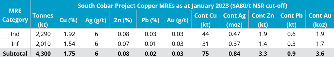
The South Cobar Project MREs including Wirlong are above A$80/tonne NSR cut-off and utilises mineable shapes, which include minimum mining widths and internal dilution to bound the MREs. Figures are rounded to reflect the precision of estimates and include rounding errors.